
The first time I saw the movie Hidden Figures was under unusual circumstances. I was presenting a poster at the Lunar and Planetary Science Conference along with two students in March 2017. The conference is held every year near Houston in the Woodland Hills Convention Center, which is across the street from a large shopping mall and theater complex. The conference rented out a special showing of the movie just for conference attendees, so we decided to go. It is always fun to see a science-themed movie with knowledgable people. This audience gave the biggest laugh at the part where Octavia Spencer, acting as Dorothy Vaughan, finds a book that states on its cover that FORTRAN is easy to learn. We all knew better.
As we were standing in line for the movie, a man came and stood in line behind us. I turned around and saw that it was Dr. Matt Golombek, Project Scientist for the NASA Pathfinder/Sojourner mission and co-chair of the NASA Mars Site Selection Committee. He has been in the middle of selecting the landing sites for our missions to Mars since Pathfinder landed in 1997. I met him previously when I helped to plan and implement an educator workshop at JPL in 2002; we invited him to speak to the teachers about his experiences with Pathfinder and with selecting landing sites on Mars for Spirit and Opportunity.
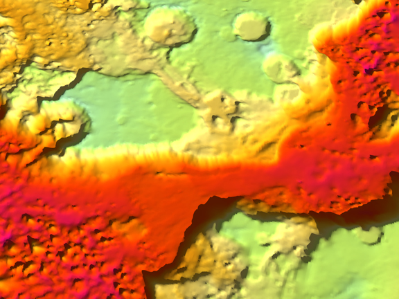
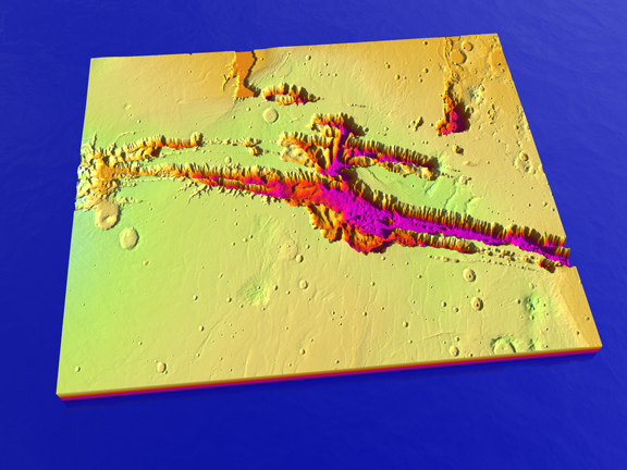
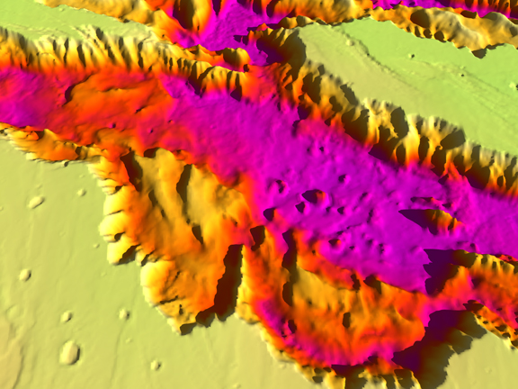
I said hello and acknowledged that he was having a very busy year. He told us that the committee was working on deciding three different landing sites that year: one for the InSIGHT lander that would finally be traveling to Mars the next year, one for the Mars 2020 rover (since named Perseverance) and one for the European Space Agency’s Franklin Rover, both scheduled to launch in 2020. The 2020 rover had had its landing sites narrowed down to three candidates by the time of that conference, and large posters were up in the convention center showing the sites using 3D imagery from the Mars Global Surveyor MOLA data and the Mars Reconnaissance Orbiter’s HiRISE camera.
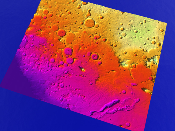
The finalist sites were to return to the Columbia Hills in Gusev Crater, where signs of a hydrothermal vent had been discovered; an area at the northeastern edge of Sirtis Major where there were many river channels leading down into Isidis Planitia; and Jezero Crater, also at the edge of Sirtis Major where there were large delta deposits and a nice flat landing area nearby.
There are a number of challenges in choosing a landing site. It must be flat enough for a safe landing, without major boulders or craters or slopes that might spoof the radar landing system. It must be close enough to areas of high scientific interest that only a short drive is necessary to reach them, or ideally the landing ellipse is right on top of areas of scientific interest so the rover can go to work immediately upon landing and instrument check-out. If it has solar panels, then it needs to land near the equator to have enough sunlight and to survive martian winter. If it has RTGs (radio-thermal isotope generators – a type of thermocouple powered by the heat from the radioactive decay of plutonium) such as Curiosity does (as well as Perseverance), then it can land further from the equator and survive longer. It needs to land at a mid to lower altitude site so that aerobraking and parachutes can slow it down sufficiently for the sky crane to work. And it needs to not be near any obstructions that could prevent it from relaying data through the several orbiters we still have at Mars.
With the site selection committee that Dr. Golombek heads, scientists suggest sites for landing based on the suite of instruments of each mission and what its goals are. Those suggestions are discussed and debated back and forth by the scientific community, with some eliminated and others added. Detailed maps and images, complete with mineralogy, are created by multiple passes over the sites with our orbital probes. Gradually the best sites rise to the top of the discussions and the choice coalesces around a final few. The committee than debates and chooses the final site.
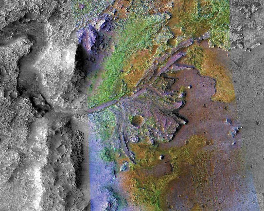
For Perseverance, the site selected is Jezero Crater (my top choice as well). It launched this July and is now halfway to Mars, landing on Feb. 18, 2021. Technically, the spacecraft is slowing down as it heads outward from the Sun; it will reach a point where Mars will intersect with it on February 18th and hopefully have a bullseye landing right next to the delta deposits. The ESA Franklin Rover has been delayed until the next conjunction 26 months from now in 2023 due to issues with its parachutes not being tested in time for the launch because of the pandemic. The United Arab Emirates has launched the Al Amal (Hope) Orbiter, and the Chinese have launched an orbiter/lander/rover combination called TianWen-1. February 2021 will be a busy month for Mars exploration.
Mars Site Selection Activity
An activity that I frequently do with my astronomy students as a means for getting them familiar with the geographic (Areographic?) features of Mars is called the Mars Site Selection Committee project. I have taught this activity many times to different groups of students and at workshops at science teacher conferences. I taught it to my astrobiology class this summer just as these Mars missions were launching. I thought it might be time to share it through my blog site and through our Ad Astra Per Educare magazine.
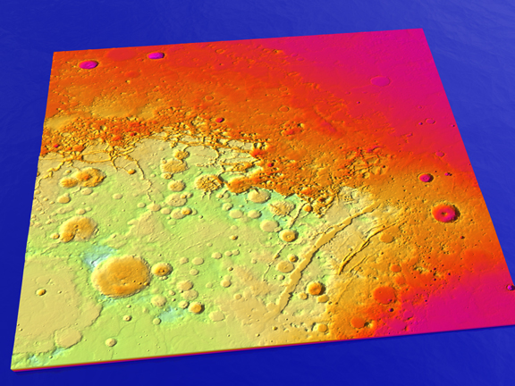
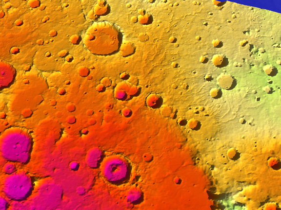
To do this properly, you need to have some large posters of Mars’ surface or be able to project an online map of Mars. I use large Mars MOLA data posters that I picked up at the Educator Resources Center for the Jet Propulsion Laboratory. At the time I was doing workshops for JPL (2002-2004), the ERC was located off site at the old Indian Hills Mall in Pomona but it is now onsite at JPL by appointment only. In addition to the MOLA data posters, they had a box full of Mars Global Surveyor posters from National Geographic. Here is a source for a high resolution MOLA map:
I also have an old Viking era poster of Mars done by Silver, Burdett and Ginn that I found in the freebies discard bin of my local library – probably a collectors item by now and quite a find. I also use the MOLA 3D altitude data found at the Mars data page of the NASA Planetary Data System node at Washington University of St. Louis (choose NASA geosciences data and it will come up, then choose Mars on the list on the left, then Mars Experimental Gridded Data Record) as an online resource. Here is the direct link:
https://pds-geosciences.wustl.edu/missions/mgs/megdr.html
The highest resolution data is at the bottom of the page. If you are unfamiliar with using .img data, then I have a whole blog post (included further down this page) and a YouTube video on this at:
or you can use an already processed height-map of Mars in .tif format that is located here:
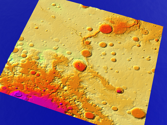
To actually run the activity, I describe the requirements for landing a rover on Mars and introduce students to the general features of Mars using my classroom and online maps. I show them the sites we have already landed at, such as Chryse Planitia, Utopia Planitia, Ares Valles, Gusev Crater, and Terra Meridiani. I show them renders of 3D terrains I have built of these sites and describe why we landed there and what we learned from each site.
I then propose a next generation Mars rover that has various mission objectives and instruments, and ask them as teams to pretend that they are representing the planetary science departments of universities and the principle investigators of each instrument. They are provided with maps or look them up online, then zoom in as much as possible to see specific features. They must find a site that has the following characteristics:
- It must be flat and level for an area about 50 km on a side.
- It must be near areas of scientific interest. If the purpose of the mission is to search for signs of life, then the site must have evidence of long-term standing or running water with sedimentary deposits of clays or other minerals that would preserve evidence of fossils.
- It must not be over 60 ° from the equator or the rover may not survive cold winters.
I allow the student teams some time to look at possibilities and I walk from team to team, describing any areas they are interested in and whether it meets the criteria. As they notice river channels, I provide names and point out features such as tributaries, meanders, deltas, etc.
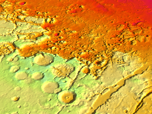
The second day, the teams choose a final site and I use the .tif file at the link above, cutting it down to a medium sized image and a smaller image of the specific landing site. I then use the procedure listed on my blogsite to print 3D models of the teams’ terrains:
https://spacedoutclassroom.com/2020/08/21/3d-printing-mars-terrains-using-mola-data/
I then use the 3D model to create renders in my 3D software, adding a gradient texture that is altitude sensitive and printing out the final renders to the teams. The medium sized data becomes a context image and the smaller data becomes a detailed image of their landing site. The teams look up information about the site, as much as they can, and create a presentation using their renders and other images they find to justify why they want to land there, based on the criteria above.
The teams then present their case for the landing site, and all the students then vote for what they think is the best site.
- For my summer astrobiology class, I had six teams and these are the sites that they chose:The lowest part of Valles Marineris at the entrance to Coprates Chasma. Lots of erosional debris is available here from canyon walls slumping. We could discover if the layers we see in the Marineris walls are volcanic or sedimentary.
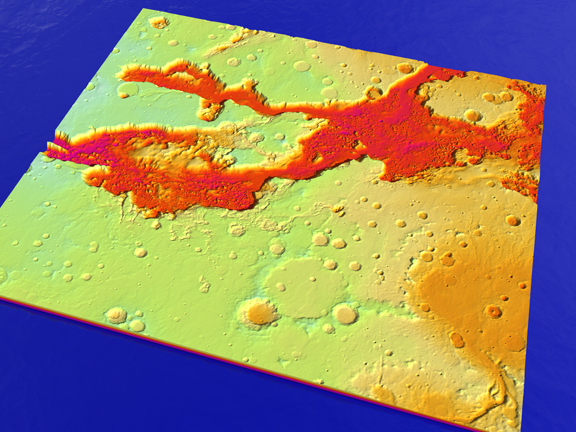
2. Further to the east, where the Valles Marineris drains through a narrow canyon toward the chaos terrain and the start of Ares Valles. Water flowed here for a long time.
3. Holden Crater, on the drainage system from Argyre Planitia toward the north after Nirgal Vallis joins the channel. It has amphitheater erosion patterns and alluvial fans that speak of ice wedging and other erosional processes. There are also delta deposits, although it is a long drive between.
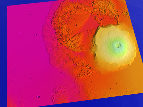
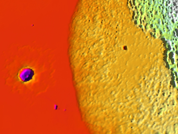
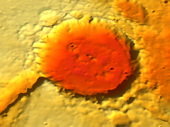
4. Tooting Crater, just to the west of Olympus Mons at the bottom of Amazonis Planitia. Their are interesting lava tubes and evidence that the ejecta from the crater was mostly mud because it left splashes that flowed, not the usual dry ejecta pattern. It is also close to the cliffs of Olympus Mons that would have been sea cliffs when this was an ocean bed.
5. The northeastern edge of Hellas Basin, where a number of river channels drain down toward the bottom of the large crater.
6. Northeast of Deuteronilus Mensae and Sirtis Major, where there are eroded mesas of sedimentary deposits along with ancient clays and recent sand dunes. This was one of the final three sites for Perseverance.
The final vote came out strongly in favor of Tooting Crater. The team did a good job of addressing all the criteria. Second choice was NE of Sirtis Major and third choice was Holden Crater. I hope scientists take an interest in Tooting Crater, as it really is an interesting site, given the lava tubes, splashed ejecta, and access to Mons Olympus volcanic deposits as sea cliffs. If we follow Elon Musk’s vision of a city on Mars, this would make a good site.
I think the activity went quite well, and it certainly fulfilled its major objective, which is to help students learn the features and geologic history of Mars.
